Bigfoot Threw A Rock At Me

E979E34B-2ECD-4AEA-B7A0-2272166A221A
The eerie but beautiful Oregon Coast Trail

For the record, I don’t believe in folklore legends like the Yeti, the Loch Ness Monster, or the Headless Horseman, but when I decided to hike a section of the Oregon Coast Trail this summer, I did not expect anything other than some sea mist and tall trees. What I actually came across that day was something that may have challenged those beliefs.

I have watched all of the same documentaries that you have about the legend of the Pacific Northwest, Sasquatch (a.k.a. Bigfoot). As a child, these documentaries terrified me and gave me no desire to ever go into the woods of Washington and Oregon. Seeing the grainy video of Bigfoot walking through a clearing in the trees was enough to give me nightmares.

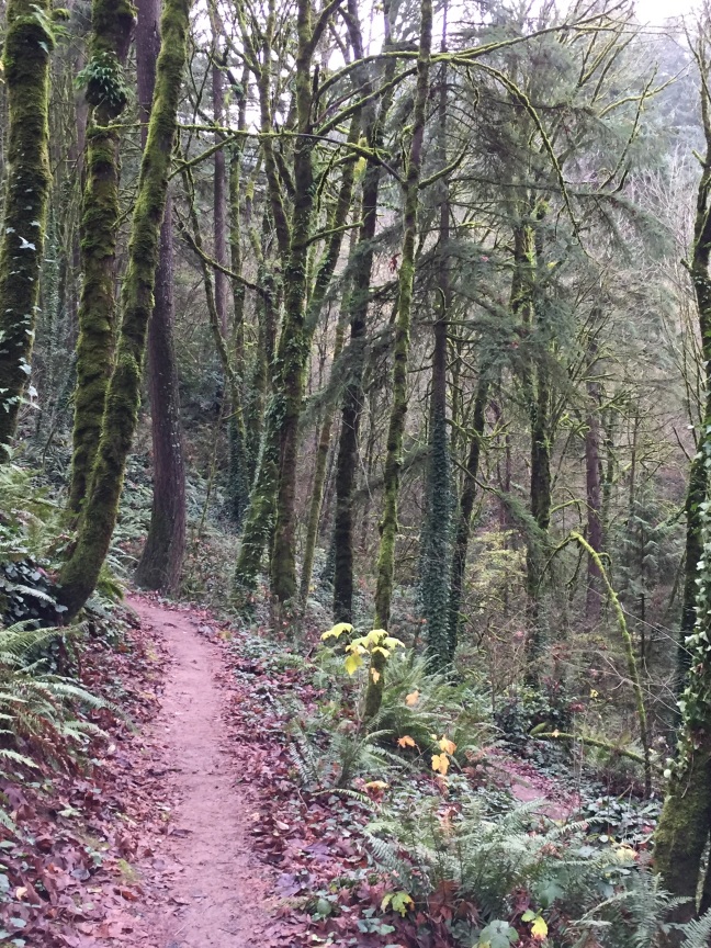
The section of the Oregon Coast Trail I decided to hike (alone I might add) was in Oswald West State Park, near the town of Manzanita, about a two hour drive from Portland. I was planning an out and back and decided I would turn around when I got tired. So I did an about face and headed back towards the trailhead after two uneventful miles, due to a cold wind and tired legs. As I was descending the overgrown and narrow trail, I heard noises ahead of me that I have never heard before in the forest. Granted, I was in a different part of the country and there are always unique and unfamiliar sounds in the wilds of a different region, but what I heard was what sounded like a baseball bat striking wood, but this didn’t overly concern me. My initial reaction was that there was a black bear ahead of me turning over logs looking for food and/or crashing through the brush, but the sounds didn’t quite match what I could rationalize as being a bear. As I approached the section of the trail where the sounds were at their most intense, I stopped to see if I could see anything moving in the thick underbrush, at this point still expecting a black bear. I saw only thick green vegetation.  After only a few seconds, I heard what sounded like three or four objects being dropped from the trees in different spots. This too did not make sense to me since I could imagine maybe a single pine cone falling from the trees but not three or four in rapid succession. I was very confused about what might be making these sounds. Maybe squirrels were dropping little pine cone bombs onto a bear below them to scare it off? This seemed plausible but not likely.

What happened next was one of a few times in my life that I have literally felt the hair on the back of my neck stand up. As I continued looking into the dense forest, an object that looked like a rock came flying out of the thicket and landed about 20 yards away from me. This had an effect on me which I have never had on a hike in my lifetime, it was such a disturbing feeling I couldn’t get to the trailhead and my car quick enough. I hauled ass out of there and made it to my car without further incident and didn’t hear or see anything else, but was still rattled by what transpired.

73C9B63E-23F4-439F-BDE3-CAFDF2FD491F

So what was it? Maybe it was a bear (but bears don’t throw rocks.) Squirrels can drop things on unsuspecting life on the ground below them but the object that came towards me didn’t fall from a tree. In Colorado, where I live, a mountain biker was killed last year while he biked on a trail near Colorado Springs and the person responsible has not been caught. At the time of this writing, a college student is missing on the same mountain and I hope his disappearance is not related and that he returns safely. It makes me think though that there may be someone that doesn’t want people in the area. So maybe there was someone up there who is trying to scare off hikers because they are getting too close their property, or they don’t like the hikers passing through. Maybe it was someone just having a little fun at my expense? I had just passed two hikers, the only two I saw on the entire hike.

Or maybe it was Bigfoot?

7DD66BD7-A2BB-42B9-A45F-A7F729C51D65

Victoria: Biking, Beer and British Columbia

I didn’t know what to expect when I boarded the ferry in Port Angeles, Washington for the 90 minute ride through the strait of Juan de Fuca heading for Victoria, British Columbia. My wife and I were planning a day of bike riding through British Columbia’s capital city but we were going at this without much of a plan. Normally, I like to plan things to a meticulous degree but this time the plans were essentially out the door.

I had read a little bit about Victoria online and I wasn’t really sure if there was enough to do there to make a full day trip out of it. My parents had gone here before and said they wouldn’t go back and actually declined our invitation to join us.  At a minimum, we thought maybe the bike ride would be nice as there seemed to be several decent bike paths throughout the city. So we decided to give it a try, booked the ferry fare, grabbed the bikes and went across the strait to see what happens.

4E9131C9-A6E4-4700-B0FF-888BEE0011EA.jpeg
Bike racks on the ferry

As a starting point, Port Angles is not the most scenic way to begin the journey but it felt safe and there were lots of families around getting ready for the ferry.  The trip across took about 90 minutes and wasn’t particularly interesting until the final approach to the inner harbor of Victoria. As you approach the city, there is a lot to see, all at once. There are really cool (tiny) water taxis taking people from one part of the harbor to another, seaplanes are taking off and landing in the middle of the bustling harbor center, kayaks and paddle boards are all over the place, and all of this could be seen before the ferry even docked. Reasons to be encouraged? Yes!

B98AF95F-9523-4E55-A099-C7DA21EA7719
The Inner Harbour

Once we landed, bagpipes could be heard along the waterfront while totem poles and stately buildings could be seen on all sides. Although the area was busy, it definitely had a relaxed vibe that you don’t get in some of the larger cities and I felt comfortable here straight away. After a quick stop at the Visitor Information Center to get our bearings straight, we headed across the bridge to the Galloping Goose Trail and followed it for a couple of hours before turning back to the city. The trail system here is well maintained and there were many offshoot trails that could be taken in most any direction. Tempting yes, but we only had a short stay and had the city center to explore still.

BC23AC86-A304-443A-8D91-FAE7AB916930
The Fairmont Empress Hotel

Next up for us, and it’s this way when I travel anywhere, is to sample a local brewery or two. First up and very near to the bike trail was the Canoe Brewery and Restaurant which had a great patio that overlooked the water and was a perfect spot to have a drink after being out on the trail (I had the Helles). While siting on the patio, seaplanes fly overhead, making this one of the more unique places to sit and have a beer that I’ve been to. After that was a short half mile pedal to Vancouver Island Brewing which is a little off of the main tourist route (but not by much) and was worth the extra time and effort. The brewery sits just outside of Chinatown which is the oldest Chinatown in Canada and was also worth the visit.  There was a greater selection of beers here and a flight was only $5, which made trying four different styles the way to go. I recommend the Twisted Stalk Blackberry Helles but all four of the beers we tried were very good.

E64DBCE6-F57A-4172-AF69-453E232DA6FA
Great beer and a great logo!

Short on time, we made a quick detour into Chinatown to have a look at Victoria’s Chinatown and the world famous Fan Tan Alley.  I love strolling through city alleys (at least the safe ones) and this was one of the best ones I’ve seen. It was impossibly narrow and barely fit the bike down the narrow lane.  Even still, biking was definitely the way to get around the city.

1BA0C709-D41E-4516-9E02-C8258B4AC349
Fan Tan Alley, Chinatown


After Chinatown, it was back to the ferry for our late afternoon departure and we were regretting our decision to not spend more time here and we didn’t even visit the number one attraction in bike pathsVictoria, Butchart Gardens.  I am not in a position to say how much time you need to explore this beautiful city but I can tell you that one afternoon was definitely not enough. At least a couple of days next time!

The Quest for Lava: Kilauea Volcano

I sat in a helicopter with no doors, buckled tightly and quite nervous, looking at flowing and glowing lava for the first time in my life. We were still over 3,000 above the lava flows that were both beautiful and very destructive.  There were fountains and rivers of molten rock making a path to ocean and taking out homes, and anything else in its path, along the way.

This would be my second time in Hawaii, with the first visit having missed the goal entirely of seeing red hot liquid magma, while the second trip took a helicopter ride on my last day to finally see it. There were many attempts prior to the helicopter ride, all ending up in failure, but failure in this case was definitely a wild ride.

Ever since I was a kid, I have always wanted to visit the Big Island of Hawaii. I can remember photos of exotic looking black sand beaches, tropical fish, and active volcanoes. But for me, seeing lava flowing from an active volcano was definitely the number one draw. I wanted to see lava, actual lava, spewing from the Kilauea Volcano, just like I had seen in pictures and videos. Kilauea volcano has been erupting essentially nonstop since 1983 (since I was in junior high school) and getting to see a live lava flow with your own eyes is pretty much a slam dunk, at least that’s what I thought. So with family, I was fortunate to get to visit the island of my dreams for the first time and try to check off a couple of other bucket list items while we were there.


IMG_0260
At least there aren’t any ‘real’ hazards to worry about!

We arrived in Hawaii and made plans to see the sights, including Kilauea, which is mostly located within Hawaii Volcanoes National Park.   Inside the park, there is evidence of volcanic activity everywhere with steam rising from the ground in many places along the rim and a large amount coming out the Halemaumau Crater, the main and largest crater in the park. However, there were no rivers of lava anywhere that we could see from inside of the park so we waited until it got dark to look at the crater at night and could see the orange reflection of lava in the clouds of steam. This was still pretty cool but not the rivers and fountains of lava I dreamed about as a kid, and it certainly wasn’t seeing lava directly with my own eyes. Reflections don’t count!

We decided to come back to the park later in the trip and hike into the crater of Kilauea Iki (Little Kilauea).  The hike is a four mile loop hike that starts in a rainforest at the rim of the crater, descending onto the barren crater floor.  The hike starts at the Volcano House in Hawaii Volcanoes National Park, with a restaurant and gift shop on the rim.  As you step out of the Volcano House and into the rainforest, you’ll be in perhaps the closest example of a ‘perfect’ rainforest you can imagine, almost like what you think of when you imagine what the Amazon rainforest would look like. The greens are greener, the foliage is denser, and all of this is as you descend into a volcanic crater where the terrain couldn’t be more different.

IMG_1318IMG_1316

The crater floor is paved with thick black hardened lava that resembles a highway that has suffered massive earthquake trauma, minus the painted lanes and auto traffic. As you walk along the valley floor, steam shoots out of small cracks in the rocks and is a subtle reminder that you are very close to the core of an active volcano.  Kilauea Iki however, is not the place for active flows, it’s just a great place to hike in a crater that once had a massive fountain of lava pouring from it way back in 1959.  As an added bonus, there is an excellent lava tube, the Thurston Lava tube, just a short distance from the main trail.  It’s well worth the extra half a mile or so that gets added onto the total hike and it is one of the most visited sites inside of Volcanoes National Park and all of the Big Island. This hike had evidence or lava everywhere, it just didn’t have the hot flowing kind. So we left Hawaii this time without seeing lava but otherwise the Big Island was, and is, an amazing place to spend a couple of weeks. We would return two years later to a very different volcano.

IMG_1311
The crater floor

This time the volcano was going nuts. You’ve all heard how devastating the Kilauea Volcano has been from news outlets this year with so many people losing their homes to the lava flow. I have so desperately wanted to see this rare phenomenon but not in this way, while people are losing their homes.  So I was conflicted but ultimately felt like I was not disrespecting anyone by simply wanting to witness it myself.

We set out from Kona one day for the long drive out to the Puna district in search of lava with hopes of seeing it in an area where homes weren’t being immediately threatened. We made our way to Pahoa where the first signs of the volcano could be seen. The first hint that anything at all was happening was the discolored smoke that was rising from the area just south of town and it was in the town where there was a command center set up for coordinating rescue efforts. This was truly the first time I felt like trying to see the lava was something more than just a cool thing to see, it was truly an active situation affecting the lives of people in a real community.

The roads leading in and out of the active lava flow area were either closed or only open to local traffic and were guarded by local police along with the Hawaii National Guard.  We drove to a couple of these roads and were turned around by the blockaded intersections. I was beginning to get discouraged but found one back road on a map that looked promising and might yet yield an opportunity to see the lava flow from close up. It was a very small road that followed the shore line and it showed that it would eventually lead an area that would get us very close to the flow. As we rounded the last turn in the road before getting to this spot, there was another blockade with the National Guard controlling access to the area.  This was a devastating blow to my hopes but the soldier pointed us down the highway back towards Pahoa, and according to my maps, would lead us right past the open fissures.  As we drove along this road, there was a slight ridge between us and the lava flows and it was just enough to prevent a sighting.  That was it! No lava for me! Only I could manage to not get to see lava when a volcano is in full eruption mode. Perhaps it was all for a reason that I didn’t get to see lava that day.


IMG_7386
From 3,000 feet above the lava flow and a very creepy dark shape just to the right of the lava!

So after a lifelong desire to finally witness this incredible natural event, it was, admittedly not exactly under the circumstances I had hoped for.  I feel fortunate to have seen the incredible power and beauty of Kilauea and I hope the families that have been displaced can rebuild their homes and their lives.  I did achieve a bucket list goal and it was incredible. Now I have added a more specific bucket list goal: to see lava while standing on the ground, close enough to feel the heat. Maybe to a place where the flows are not threatening homes or lives? Maybe a trip to Vanuatu?

Durham, North Carolina: A Bucket List Destination?

IMG_5718
Inside the Duke Chapel

With well known destinations like the Outer Banks, the Great Smoky Moutains, and Asheville, most people don’t normally choose to visit Durham when deciding where they want to go in North Carolina.  My wife and I chose Durham so we could knock something off of her bucket list: a Duke University Men’s Basketball game.  We were spending three days in and around Durham with the game being the highlight of the trip.  So without knowing much about the area, we set out to make a weekend of it.

Day One – The Search for the best BBQ and Beer

Quite literally, our first stop after getting our rental car was to find a great local Carolina BBQ restaurant. I’m very drawn to the small ‘mom and pop’ type of place and always check to see how it rates on popular crowd sourcing sites before committing to having a meal there.  So after a little research, Backyard BBQ in Durham was the obvious choice.  It’s located in a benign strip mall, but don’t let that fool you, the food is outstanding, the service is friendly (especially for first timers like us),  and the prices were low (around $10 for a meal). The meal came with something I’ve never had – hush puppies, which are basically deep fried balls of cornmeal. Every culture seems to have a deep fried equivalent like sopapillas, funnel cakes, zeppolis, or beignets.  All taste great but beignets from New Orleans are still probably my personal favorite.

After filling up on Southern BBQ, we headed out to see some of the small towns south of Durham (I’m not much of a city guy). So we followed a tip from from the person working the tourist desk at the Raleigh-Durham airport and headed out to Apex, Pittsboro, and Chapel Hill (I know…Chapel Hill isn’t exactly a small town and is decidedly anti-Duke). Apex is really just one block of shops on Salem Street and didn’t quite live up to the charm we expected. That being said, it was still a nice walk and it was really what we needed after eating too much for lunch so after a quick spin around the block, we decided to drive down the road to Pittsboro.  Although it wasn’t significantly different than Apex, it had just a bit more charm and appeal. While there, we visited artists and craftsmen at the Joyful Jewel which is a shared space for locals to display and sell their work.  While browsing we ran into a local soapmaker whose soaps looked more like art than a way to stay clean.  Not far from the main shops along Hillsboro Street is the Chatham County Courthouse.  It’s a beautiful building which was first constructed in 1881 and sits in the middle of a large, and busy roundabout.  You can’t miss seeing it and we decided that it looked worthy of taking a closer look. As soon as we entered the building, we were immediately greeted warmly and excitedly by someone from the Chatham County Historical Society and she immediately took us on a tour of this most Southern of courthouses. She was full of great facts and stories not just about Pittsboro, but of the entire area. And those who have never been, Pittsboro also has one of the greatest ‘landmarks’ of the Southern United States, a Piggly Wiggly supermarket! Although not much more than a standard supermarket, it is a must stop just so you can take a quick selfie by the sign and say you were at a place with such a famous, funny, and interesting name. The last stop on our small town tour of day one was Chapel Hill, home of the University of North Carolina.  Chapel Hill is not a small town but it does have a great college town vibe, even for those who consider themselves Duke University basketball fans. The mission in Chapel Hill though had nothing to do with college rivalries, but instead was more of a beer quest.  The place to be in Chapel Hill is Franklin Street and it is there that we found the Carolina Brewery.  It had a really nice atmosphere and it was a good place to grab a beer and appetizers.  Day one done!

IMG_5708
Chatham County Courthouse


Day Two – Duke University and the Bucket List

This day is all about Duke Basketball and the Cameron Crazies. We arrived early so we could walk the campus a bit and explore the Duke University campus, which has to be one of the most beautiful campuses in the country to stroll through.  The centerpiece of the campus surely has to be the Duke Chapel, a gothic style cathedral which is stunning both inside as well as out.  The campus is very walkable and we were able to get to Cameron Indoor Stadium, where Duke plays, in just a few minutes. The “stadium” feels nothing more than a large high school gym, but it’s so much more than that. The student section is truly one of the most unique and entertaining spectacles in all of sports.  The students are called Cameron Crazies and they chant, dance, cheer, jeer and just have a great time being college kids.  They have a lot to cheer and be happy for, as their basketball team is perennially among the top programs in the nation. My wife has always been a Duke fan and I was a little slower to hop on the bandwagon but after seeing so many games on television with her and seeing how crazy the students were, I gradually became convinced that this was the college basketball team for me too, and I actually really don’t even consider myself a basketball fan! It was truly an incredible experience even if you just watch the students!

IMG_5728
The Cameron Crazies

Day Three – Hiking and More Small Towns

My day started with a cold morning hike in Eno River State Park and some much needed exercise.   Although the hike wasn’t particularly scenic or difficult it always feels great to get outside and get some fresh air and see some new terrain. After the hike, it was time to see a couple more small towns before going to the airport and heading home. Our first stop was the small town of Hillsborough and more BBQ, this time at the appropriately named Hillsborough BBQ Company. I had the brisket, which was fantastic and more hushpuppies, now that I knew what they were. After Hillborough, it was on to Saxapahaw, which has to be one of the most fun names in the world to say…Saxapahaw.  Aside from saying the name of the town, we liked it for the Haw River Ballroom which used to be the dye house in the cotton mill and is now a happening concert venue.

IMG_5747
Eno River State Park


Verdict

Durham, for us, was almost exclusively a trip centered around the bucket list item of seeing a Duke Basketball game at home. The days on either side of the game were mostly spent visiting small towns and trying southern cooking. I would someday like to return during the summer to see what it’s like when the weather is warm and there are leaves on the trees.  Having visited in the heart of winter, I felt like there wasn’t much to do for the active traveler. For a great place to stay, try the Arrowhead Inn Bed and Breakfast, a massive and beautifully maintained home that was once an 1800’s plantation. A large stone arrowhead sits on the corner of the property, marking the location of the old Indian Trading Path. It was in a nice quiet part of town, had great hospitality, and the food was excellent.

Turks and Caicos Islands

Turks and Caicos Islands (TCI) is not the place most people think about when they think about traveling to the Caribbean, but not because it isn’t the idyllic tropical island of most people’s dreams.  TCI are located just north of the island of Hispaniola and south of the Bahamas. These islands were really just only recently discovered by travelers and the infrastructure to develop tourism is just now gaining some momentum.  But if you’re looking for crystal clear blue water, and by that I mean the clearest and warmest blue water around, this is the place for you!

IMG_4515
Chalk Sound National Park

My visit to Turks and Caicos was to the most developed island in the group, Providenciales.  It is known locally as ‘Provo’ and is served by an international airport but not by cruise ships.  Not having a deep water port for the ships means less people and to me, this is a very good thing.  Provo has what has been voted as one of the best beaches in the world, Grace Bay Beach.  The beach is largely uninterrupted for around seven miles and has hotel properties and beach villas all along its shores.  I stayed on the eastern side of the island in an area called ‘Leeward’ and was happy being there due to the fact that is was away from the hotels and was much quieter than the main part of Grace Bay. Although Grace Bay is quite beautiful, to me it was a little overrated. Beautiful beaches and clear blue water can be found all over these islands and to me, these other beaches had a lot to offer, with a more natural vibe than Grace Bay. Here is a small sample of some of the other places we visited that might be a little lesser known, but were well worth exploring:

Chalk Sound National Park

If I had to pick what I thought was the most beautiful spot on Provo, I would surely pick Chalk Sound. The water here is the most outrageous turquoise blue I have ever seen anywhere in the world.  There isn’t much of a proper beach, that I could find, so we rented kayaks to explore the bay. Rent them at Las Brisas Restaurant (sounds weird to rent kayaks at a restaurant but it was just fine) and paddle into the blue.  It’s also a great apres kayak place to recharge.

Middle and North Caicos

Provo is a developed island with tourist infrastructure, five star dining, and decent roads.  The islands of North and Middle Caicos are absolutely none of that.  Tourism is virtually nonexistent, finding an actual restaurant was purely accidental (found a good one though in Mudjin Harbour), and the roads weren’t so good and poorly marked.  It was awesome!  Have you ever seen flamingos in their natural state? Ever been to a real live bat cave? Tropical beaches without people, any people?  Take a day trip from Provo and enjoy some time away from the crowds.

image
Mudgin Harbor -Middle Caicos

Barrier Reef Snorkeling

From shore, there isn’t a tremendous amount of sea life to see, at least from what I experienced.  This is why a snorkeling trip out to the barrier reef is the more desirable option.  Big Blue Unlimited offers a package deal where you snorkel the reef, walk with the iguanas of Iguana Island, and visit the pristine and deserted beaches around Fort George Cay. The guides are top rate and the snorkeling was pretty good, although not as good as some other places I’ve been (like Hawaii). During the reef trip, we saw barracuda, parrotfish, and even squid.  Iguana Island was worth the stop but for me the highlight was the boat ride out to Fort George Cay.  Sitting on the bow of a fast moving boat over crystal clear blue water was something I could do every day of my life and never tire of it.  The boat seemed to fly over the water and couldn’t have been smoother.  To top it off, the boat stopped at a deserted beach where we ate fresh fruit and brownies while listening to the other guests discuss such wide ranging topics like Argentinian politics, life in the islands, and traveling to Cuba.

IMG_0479
Fort George Cay

Find Your Own Beach

I’d say the most relaxing beach we went to happened to be right by the place we rented. We could start and end our day by walking a couple of hundred yards to the water where we’d find only two or three people on the sand or in the water. We brought my wife’s stand up paddle board down with us and just splashed around, content to be relaxing at a beach we didn’t even know the name of.

FullSizeRender 3.jpg
Lone Yellowtail at “our” beach

Know Before You Go

You don’t need more than maybe five or six days.  Any more than that and you may run out of things to do (which may be exactly what you’re looking for).

Be ready to fork out big bucks on food if you don’t stay at an all inclusive. These islands are among the most expensive in the whole of the Caribbean.

The islands felt mostly safe.  There were a couple of areas that felt a little uncomfortable at night even though nothing ever happened to us.  However, in the weeks after leaving the islands, two Americans had been shot in separate robberies. In hindsight, those ‘uncomfortable’ moments now seem a little unsettling.

The tourist bureau touts the Thursday Fish Fry as the big thing to do where locals and tourists mingle together to eat, drink, shop, and listen to island music.  There is really no mingling between the locals and the tourists unless you consider buying something ‘mingling’. The food was the same food you can get anywhere on the island, the music was average at best, and the atmosphere was a little bit like that of a flea market.

So would I go back…maybe!

IMG_0481
License plates with flamingos…check!


Waterton Lakes National Park

Canada’s Waterton Lakes National Park is one of those wonderful surprises you find in life when you least expect it.  My wife and I visited the park sandwiched between a trip to perhaps more recognizable destinations Glacier National Park in Montana and Banff National Park in Alberta. To get to Waterton from Glacier, you either have to hike, which isn’t practical for most people, or you have a two hour drive with a border crossing.  It is considerably longer to get to Waterton from the Banff/Calgary area, about four hours from the town of Banff. So most people never make it here and that’s too bad for them but it’s great for those who are looking for a less crowded park to experience.

IMG_0388
Black Bear- Courtesy of Kimberly Wallace

So aside from being less crowded, why visit this hard to reach park?  For one, the small townsite of Waterton Village has a great vibe.  There is really only one main street, Wind Flower Avenue, in the town and it has a handful of restaurants to support the summer ‘crowds’.  It has an an ice cream shop, the Mountain Top Yogurt Shop, that served a Saskatoon Berry Pie that I had not even heard of until visiting the area.  Saskatoon berries are kind of a cross between blueberries and huckleberries and are very good!  The town is a little bit touristy but not over the top like shall we say…Banff.  There is also a nice walking path in town that follows the lakeshore and walking it on a summer evening, which in our case was 10:30 with still plenty of light left, is a good way to walk off that Saskatoon berry pie.

One of the more popular activities to do on the lake is to take a boat ride on the M.V. International from the town of Waterton to Goat Haunt on the American side of the lake.  It is a great way to relax and see the sights of the lake.  You get to see the USA-Canadian border from the boat and I must admit it seemed a little weird. It was almost like what you see in a Bugs Bunny cartoon where you can see the lines of the states when they’re in a plane getting ready to parachute out. Only here, the trees are removed from what looked to me to be about 30 yards wide worth of border to make a very clear, distinctMaybe there will be a wall there someday. 😉  When you get dropped off at the Goat Haunt ranger station, you’re now in Glacier National Park and the United States of America, making it one of the most unique border crossings either country.  To make it even more memorable, I got pranked by the US Border Patrol. More about that in a future story.

IMG_0383
Waterton Lake – Photo courtesy of Kimberly Wallace

If you’re lucky enough during the short summer nights, you may have a chance to see the northern lights.  There are several factors at play in order to see them: for one, the night must be clear or clouds, second you really need a good vantage point, and finally, there needs to be solar activity.  So while at Waterton, I had two of the three with only the solar part needed.  So I did what any trained woodsman would do, I used an aurora borealis app on my phone. The app predicts, with great accuracy I would later find out, the appearance of the lights in the area you’re in.  Technology like this is both amazing and a little bit sad but if you’ve got it, you may as well use it. The app was predicting a very active night for the aurora so I went down to the lake and waited for a what turned out to be a couple of hours.  I watched as the predicted time for the northern lights to appear and within about five minutes of when it predicted the solar storm would start, I could see a green blob moving towards me from the northeast.  At first I thought it was just light pollution from Calgary, to the north, but that seemed unlikely since this blob looked like it was moving.  Even still with what was obviously a green blob of aurora borealis heading my way, I still couldn’t quite believe my eyes. I’d never seen anything like it before or since.  It was incredible! The color that night wasn’t as bright as you see in some of the great photos but it was still green and danced across the sky at speeds that were mind boggling.

IMG_0461
Northern Lights from nearby Lake McDonald photo via good free photos

The following day, we decided to take a lake cruise onboard the M.V. International from Waterton Village to Goat Haunt on the American side of the lake in Glacier National Park, Montana. The ride takes about 45 minutes on what has to be one of the prettiest lakes in the Rockies. The boat stops at Goat Haunt for about 1/2 hour but  you can hang around longer if you like and hike if you make arrangements with the tour company, and if you have your passport ready for what might be one of the most unique border crossings anywhere. We decided to stay and hike but going through a hike-in border crossing with real gun toting agents was definitely something that I’ve never done before.

IMG_0391
Nighttime at the Prince of Wales Hotel – Photo by Kimberly Wallace

So our accommodations on this trip were exclusively in our pop up camper and we enjoyed it immensely but for one night, we treated ourselves to a stay at the Prince of Wales Hotel, an incredibly beautiful hotel with one of the most amazing views a hotel could ever have.  The hotel is situated on a hill of the town and lake looking south towards the United States.  As we pulled into the parking lot, my wife spotted a black bear (her first) eating Saskatoon berries in the field. It was a great way to be introduced to this fine hotel.  We watched and photographed the bear for about an hour before heading inside.  While inside, we heard that someone got too close to the bear and it charged him.  Anyway, the hotel has a sort of Scottish hunting lodge feel to it even including the hotel staff wearing kilts.  It was a unique and enjoyable place to spend our last night at what turned out to be a great Canadian National Park.

IMG_0460
Prince of Wales Hotel via Good Free Photos

I can tell you with a straight face that we enjoyed Waterton Lakes National Park even  more than we did Banff National Park, and that is saying a lot.


Top Five Places for Key Lime Pie (in Key West)

FullSizeRender
Key Lime Pie Company


Creating a top five list of the best key lime pie in Key West is a tough job but someone had to do it, so it may as well have been me.  Just a couple of provisos regarding this list:

This is based upon my likes. I like to taste the lime, not to be overpowered by it but I do think it should be the primary flavor I taste. The crust needs to be good but honestly, most of the pie that I tasted had virtually the same style graham cracker crust.  Last but not least I like a thick and consistent texture.

This is obviously not an exhaustive list! It is nearly impossible to try every restaurant’s version of the world famous key lime pie. So if you’ve been to the Keys, you may ask ‘how could you miss this place or that place?’ so it will take loads of additional research before I can complete this task.  I encourage you to let me know if you have a favorite key lime pie and I will be happy to check it out.

Price is not a factor in any of the decisions here. I have based my decisions only what I think matches my tastes. It is not for me to decide how much is worth it to you to pay for a slice of pie.

So here it is, the Native Trekker ‘Top Five Places for Key Lime Pie in Key West’


5. Key Lime Pie Company

The Key Lime Pie Company had a really good pie. The pies are made behind a glass window so you can see the magic as it happens. This pie had very good texture along with a standard pie crust. The only disappointing trait of this pie was the lime flavor was slight, almost hard to detect.  This was one of the larger proportioned slices sampled and was the lowest priced among the top five.

4. El Meson de Pepe

This place has really got it going on! With great Cuban food and the best live music we heard while in Key West, the only thing it needed to make it even better was a great slice of Key Lime. It delivered with a meringue style pie with a lime syrup drizzle that made it one of the more unique flavors we tried. This pie had one of the strongest lime flavors on the list which was great.  The texture wasn’t quite as thick as some but overall this was a very good pie and you can have it in perhaps the best atmosphere in Key West.

3. Blue Heaven

This place is another Key West locale with a great vibe.  The outdoor seating area resembles some of the great courtyard restaurants in Santa Fe but with a tropical theme.  Blue Heaven has a great combination of lights, trees, and even wild roosters to go along with their version of how to do Key Lime Pie.  Theirs is another of the Lime meringue style and it didn’t disappoint. It had a great blend of lime flavor, with a good crust and texture.

2. Margaritaville

Jimmy Buffet’s entry on this list may come as a surprise to some but we have consistently had really good Key Lime Pie every time we’ve been there. The atmosphere at Margaritaville is very different than the others on this list and has more of a cheeseburger in paradise feel to it, with music videos playing on a giant screen with a pirate like decor.  The pie had a nice thick texture with a really good crust. The only thing that could have made this pie any better would be for a slightly stronger lime flavor. They even get double bonus points for giving you your margarita in a to-go cup!

1. Banana Cafe

The Banana Cafe ended up being a real surprise to us as the number one Key Lime Pie in Key West.  Despite its name, this is primarily a French style restaurant and it made the best Key Lime Pie of anywhere we tried.  Although Key Lime Pie is not often associated with French food, it is a ‘must have’ if you want to have a restaurant in the Keys. So if you look at the criteria I mentioned in the beginning, the Banana Cafe checks all of the boxes.  Great crust, texture, and most important to me, I want to taste the lime and I certainly did.

So there you have it! The Native Trekker Top Five Places for Key Lime Pie in Key West.  I plan on returning to try more and turn this list into a Top 10 someday. Maybe the next list will be a comprehensive Key Lime Pie list of the entire Florida Keys, who knows. The research has exhausted me and I need time to recover.

Cheers

P.S. – I’d love to hear if you have any suggestions to check out for next time!


What makes Portland, Portland?

So what does make Portland uniquely Portland?  Oregon’s largest city is known for being different, weird if you will. It has a green fetish that’s hard to ignore, trendy restaurants, a great mass transit system, and an affinity for two types of beverages: coffee and beer.

This is my second time visiting Portland.  A couple of years ago I was there with my parents for a few hours but really wasn’t there long enough to pick up what kind of vibe this place was laying down.  We managed to hit only one brewery, Deschutes, and a couple of blocks away, Powell’s City of Books and that was pretty much it.  On my second and most recent visit, this time with my wife, we had four days in which to try to get to know this city a little bit better.

image

So back to the question of what makes Portland unique.  First, Portland is a very green city, and in more ways than one.  So has anyone ever told you that it rains in Portland? It’s true, very true!  All that rain maks the city very green!  Most of the grass was still green, like Irish green (keeping in mind that we visited in December) and there were evergreen trees all over and around the city.  In most places, rain normally forces people back into their homes but if you let the rain stop you here, you would never see the light of day (notice I didn’t say “you would never see the sun”?). Portlanders seem to accept a rainy day as just part of life and they just get on with it. They dress for it and then get out there on their bikes or walk and get to work.

image
Marquam Nature Park

The ‘other’ green is their environmental consciousness. The mass transit system here is very good and that helps to cut down on air pollution and traffic.  They even have a bridge across the Willamette River, Tilikum Crossing, that is closed to automobile traffic.  There were many cyclists, pedestrians, light rail trains and buses using the bridge but even with all of that, the bridge never seemed crowded. I can’t help but see just a touch of irony here though.  Portland was once nicknamed ‘Stumptown’ due to it having more tree stumps than actual living trees.  Also, if you take Highway 26 west out of the city towards Cannon Beach, you’ll share the road with countless large logging trucks, trucks that are bringing timber from the forests that lie between Portland and the Pacific Ocean. You’ll see evidence of numerous clear cut areas as you continue west and it is just a bit depressing, especially when you see just how slow the replanted areas are growing.  But I get it, it is a renewable resource, it’s just a shame to see how much we use and the devastating affect it has on the environment. And lastly on the green piece (pun intended), the soccer team that represents the city, the Timbers, have a logo that is primarily made up of an axe. That logo isn’t only symbolic of its past, but also of it’s present.  Not the greenest symbol around, especially for a city famously known for it’s progressive green thinking.

image
Tilikum Crossing

For the foodie, the locavore movement here is strong with it’s ‘think globally, source locally’ mantra woven into the fabric of the Portland food scene.  Weekend markets are found all over the city and create an almost small-town feel. One trending restaurant theme is the ‘dining hall’ and Portland has a USA Today top five rated one in the Pine Street Market.  This dining hall is in the resurrected historic Baggage and Carriage building and has plenty of character. The market houses a variety of different restaurants including ones featuring ramen noodles, Israeli street food, and even an upscale hot dog vendor (my favorite).  Lastly, no trip to Portland would be complete without stopping by Voodoo Doughnuts for some of the most creative doughnuts anywhere.

image
Voodoo

So living in the rainy cities like Portland and Seattle, people need coffee to get going, much more than let’s say sunnier climes like Miami.  This means coffee shops can be found everywhere. Starbucks got its start a couple of hours north and is now a household name around the world.  Stumptown Coffee from Portland is one of the more popular coffee shops and is also a household name, at least in Portland it is.  I love hearing how a small business like Stumptown Coffee is doing so well but was disappointed to hear that it was purchased by the much larger, Luxembourg owned, Peet’s Coffee.

And lastly, Portland is known as Beervana! It does deserve this title and it boasts breweries all over the city.  I think I heard that there are over 70 within the city limits. So we tried a couple of those within the city limits, and even a couple out on the coast.  Within the city, we checked out two in the Pearl District: Deschutes and Rogue.  Both had good beers, but extra props to Deschutes for their food and comfortable, bright atmosphere.  So here’s the thing, Portland has an outstanding microbrew beer scene but there are a lot of places that can claim that they have a great beer scene too.  Like say San Diego, Boulder, Asheville, and countless others.  What does Portland have that the others don’t?  When I think on microbrewed beer and where it came from, I think of Portland! It also just feels like the kind of place where beer ‘should’ come from, certainly not San Diego (no offense intended San Diego).

So what makes Portland, Portland?  I still don’t know!  I think I came here looking for the Portland that you see on ‘Portlandia’ and really didn’t find that (maybe that’s a good thing). Places like Voodoo Doughnuts, a Portland original, don’t even scream “That’s so Portland” to me. I think Boulder Colorado has enough breweries to make Portland not seem as unique as maybe it once was.  There is a slogan in Portland that reads “Keep Portland Weird” and that saying, minus the Portland part, was actually started in Austin Texas as “Keep Austin Weird”.  It’s most famous coffee shop is now owned by a foreign entity.  It has a homeless problem.  It has beautiful parks.  The people are friendly. The people are active.  There actually is a lot of flannel being worn.  There are also beards, lots of them.

image

It is a city of contrasts, green but with a dark green past. It is a city, much like any other city.  It has some uniqueness, weirdness if you will, but not as much as I was expecting, hoping for.

I didn’t love Portland, I liked it!

And did I mention that it rains there?

image


Hike: Lost Dutchman State Park

When I thought about my first hike in Arizona this past spring, I knew I was prepared for the environment. I had lots of water, sunscreen, and a wide brimmed hat, just like everyone reads about desert hikes.  I also knew that it would be comparatively hot as I was coming from Colorado where spring is just a snowier extension of winter, to the Phoenix area where the temperature was in the low 80’s.  Hiking in temperatures in the 80’s is not too bad, if you’re used to it but I hadn’t hiked in temperatures that high in months.

image
One of the feeder trails, Jacob’s Crosscut

So when I decided to hike in Lost Dutchman State Park near Apache Junction, Arizona, I felt that I was ready for the challenge of a desert hike.  What I wasn’t prepared for was how steep the trek would be and, maybe most surprising of all, how high the altitude would be at the top, 4,861′ which is only slightly less than the elevation of my home near Boulder Colorado.  I was hiking the Siphon Draw Trail, which didn’t ‘look’ that tough on the map or even when I drove into the park, but I definitely misjudged this one. The first 1/2 or so of the trail is relatively flat with saguaro cacti all around and great views of the Superstition Mountains looming above. After a short while, the trail officially leaves Lost Dutchman State Park proper and enters the Tonto National Forest and the climb really begins from here.  About every 30 minutes or so during the hike I could hear a steam whistle from a train that runs through the Goldfield Ghost Town.  Normally man-made noises would detract from a hike, but here it added a bit of an old west feel to the area.

image
No switchbacks here!

In most places that I’ve hiked steep grades are usually lessened by switchbacks, but there weren’t too many switchbacks on this trail! The Siphon Draw Trail is mainly a vertical trail! I only managed to make it to the area known as ‘The Basin’ and only then realized how tough of a hike this really was. The final mile or so has, according to the park brochure, a 2,000′ elevation gain over the last mile! That would make it the steepest hike I’ve ever done, but today was not the day for me to pull that steep of an ascent off.  I may try it again some day and maybe make up that one mile, 2,000′ ascent.

image
The flat part
image
The Superstitions
image
Phoenix in the distance 


Boulder Colorado’s Mesa Trail

Some say that the Mount Sanitas Trail is Boulder’s quintessential hike.  The hike is 3.1 miles round trip and has an elevation gain of around 1,350 feet but to me, there are better hikes in Boulder and although the Mount Sanitas Trail is a great (short) workout, it is not the most scenic hike in the area, in my opinion.  To me, the hike that should be on everyone’s Boulder must do list is the Mesa Trail.

The Mesa Trail has almost the exact same elevation gain as the Mount Sanitas trail, but it spreads that elevation gain over a one way distance of about 6.8 miles.  It may actually be one of the flatest hikes you can do in Colorado since it parallels the mountains rather than climbing up them.

As far as scenery goes, there are few hikes anywhere in the country that can rival this one.  The Flatirons are the rock formation that you see in every tourist magazine that features an article on Boulder.  These five primary blocks of sandstone make for a spectacular backdrop for a day hike.  In additon to the Flatirons, this is one of just a few areas along the Front Range where the pine forest actually comes all the way down over the foothills and onto the prairie below.

image
The trailhead at Chautauqua

Another great aspect of this trail is its accessabiity.  The trail has three primary trailheads: The South Mesa Trailhead, the Trailhead at the National Center for Atmospheric Reasearch (NCAR), and the Chautauqua Trailhead.  Of the three, only the South Mesa Trailhead has a fee to park ($5).  All three can be very crowded in the summer tourist season and on any weekend day when the weather is good.  Go to NCAR if you want free parking and moderate crowds.  The view here of the Flatirons is really good too but go to Chautauqua for the best view (the downside is the bigger crowds.) For a less crowded section of the trail, start at the South Mesa Trailhead.  It is the least scenic of the three trailheads but it still has some decent views of the Flatirons, Boulder and even Denver off to the southeast.

image
Early summer flowers

The best part of hiking the Mesa Trail is that you have many options, and the hikes are all pretty accessible for most people.  If you start at Chautauqua and NCAR, you can walk right up to one of the Flatirons and touch them within about 20 minutes after leaving the parking lot.  Also of note is the many side trail options off of the main trail.  If you’re looking for a longer hike, the side trails heading into the hills are nearly endless and offer you the opportunity to get a workout as good or better than the one you can get on Mt. Sanitas.

image
One of many trails that can be accessed from the Mesa Trail, the Mallory Cave Trail

In my opinion, the Mesa Trail pretty much has it all: great scenery, the option for longer hikes while all are within the close proximity of the city of Boulder. For a great après hike food/beer option, check out the Southern Sun for a laid back vibe and great beer just down the hill from the NCAR trailhead.

image
For most of the winter, the trail is still accessible and can still be hiked (microspikes recommended though)