Nuclear Hiking : A walk through Rocky Flats

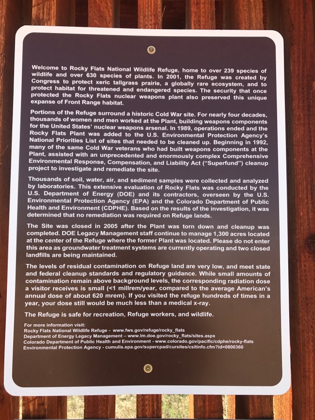
LThe land that was once considered one the most polluted places on earth has now been cleaned up (we hope) and is now open to limited recreation, known now as Rocky Flats National Wildlife Refuge.  And guess what?  You can hike there…for free!

Admittedly, this hike does have a bit of an odd feel to it knowing that nuclear triggers were made here.  However,  it did not have the ‘eerie’ feel that the area around Los Alamos has (the place recognized as the birthplace of the atomic bomb) which has a strong government town atmosphere and feels as though it holds many secrets.  Rocky Flats is more out in the open, kind of in your face, whereas Los Alamos is hidden behind trees and rocks. At the Flats, the Department of Energy still has a presence at the refuge monitoring the site. I noticed there are still large mountains of dirt being moved around by heavy machinery creating dust that gets carried in whatever direction the wind blows.  Let’s hope that this dust is nothing more than common everyday dust.

D8CB8B24-6ADB-4CCB-B8E0-9C24B845EAC8
Earth moving operations

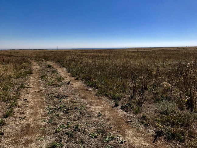
If nothing else, the refuge provides the area with some new trails to try out and is considerably different than any other hike that you can do near Boulder. There is a reason why the area is called Rocky Flats as it is the flattest hike I have done in Colorado.

7D936D4E-0A1F-4EAF-95DE-A1BB5682CCC1
The ‘Flat’ in Rocky Flats

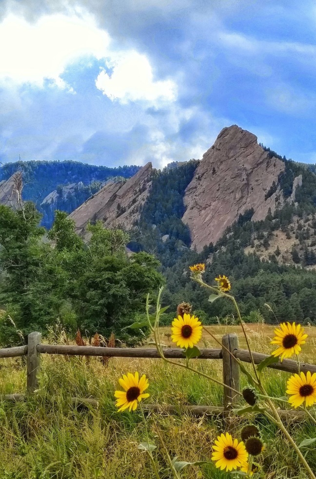
The view of the Flatirons in Boulder is very good from here but I found myself looking at them wishing I had chosen to be in the scenery instead of viewing it from a distance.

A few notes about the hike:

  1. The park service allows hikers, bicyclists, and equestrians on its 11 miles of trails.
  2. The path is mostly gravel and dirt suitable for mountain bikes but probably not road bikes.
  3. The main entrance is just off of Colorado state highway 128 and has free parking for about 10-12 vehicles. There are really no services at the trailhead but there is a portable toilet.  There was also no fee to enter the refuge, that I could see.
  4. The trail is very exposed, with only a few trees, and virtually no shade.
  5. I saw little to no wildlife during my hike, a common sparrow being the only fauna I noticed. However, I was hiking in late morning, not the best time to view animals. The park brochure mentions deer, elk, prairie dogs, coyotes, jackrabbits and porcupines as animals that you might see.
8EEACD5F-3EE8-449A-B801-EC7135227149
At the trailhead, for your reading pleasure

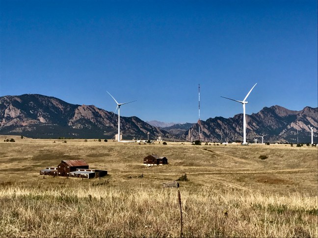
In summary, this is a place of contrasts where you have abandoned ranches next to modern wind generators, protecting wildlife in a place that once made nuclear weapons, and maybe the least important was the hike itself which was a flat prairie hike in full view of the beautiful foothills around Boulder. The hike is one that I would most likely not do again but in fairness, I haven’t seen the whole 11 miles of trails within the refuge.  If you like flat, treeless hikes with great views of the mountains, this is the place for you.  It just wasn’t for me.

I give this hike a ‘glowing’ review! 😬

3052BFB1-DE04-4572-874C-B8018A95719E
Just outside the refuge boundary, an artist with a very strong opinion

Boulder Colorado’s Mesa Trail

Some say that the Mount Sanitas Trail is Boulder’s quintessential hike.  The hike is 3.1 miles round trip and has an elevation gain of around 1,350 feet but to me, there are better hikes in Boulder and although the Mount Sanitas Trail is a great (short) workout, it is not the most scenic hike in the area, in my opinion.  To me, the hike that should be on everyone’s Boulder must do list is the Mesa Trail.

The Mesa Trail has almost the exact same elevation gain as the Mount Sanitas trail, but it spreads that elevation gain over a one way distance of about 6.8 miles.  It may actually be one of the flatest hikes you can do in Colorado since it parallels the mountains rather than climbing up them.

As far as scenery goes, there are few hikes anywhere in the country that can rival this one.  The Flatirons are the rock formation that you see in every tourist magazine that features an article on Boulder.  These five primary blocks of sandstone make for a spectacular backdrop for a day hike.  In additon to the Flatirons, this is one of just a few areas along the Front Range where the pine forest actually comes all the way down over the foothills and onto the prairie below.

image
The trailhead at Chautauqua

Another great aspect of this trail is its accessabiity.  The trail has three primary trailheads: The South Mesa Trailhead, the Trailhead at the National Center for Atmospheric Reasearch (NCAR), and the Chautauqua Trailhead.  Of the three, only the South Mesa Trailhead has a fee to park ($5).  All three can be very crowded in the summer tourist season and on any weekend day when the weather is good.  Go to NCAR if you want free parking and moderate crowds.  The view here of the Flatirons is really good too but go to Chautauqua for the best view (the downside is the bigger crowds.) For a less crowded section of the trail, start at the South Mesa Trailhead.  It is the least scenic of the three trailheads but it still has some decent views of the Flatirons, Boulder and even Denver off to the southeast.

image
Early summer flowers

The best part of hiking the Mesa Trail is that you have many options, and the hikes are all pretty accessible for most people.  If you start at Chautauqua and NCAR, you can walk right up to one of the Flatirons and touch them within about 20 minutes after leaving the parking lot.  Also of note is the many side trail options off of the main trail.  If you’re looking for a longer hike, the side trails heading into the hills are nearly endless and offer you the opportunity to get a workout as good or better than the one you can get on Mt. Sanitas.

image
One of many trails that can be accessed from the Mesa Trail, the Mallory Cave Trail

In my opinion, the Mesa Trail pretty much has it all: great scenery, the option for longer hikes while all are within the close proximity of the city of Boulder. For a great après hike food/beer option, check out the Southern Sun for a laid back vibe and great beer just down the hill from the NCAR trailhead.

image
For most of the winter, the trail is still accessible and can still be hiked (microspikes recommended though)